References

1")
Marine Technology Company is a non-profit organization, and its main activity is research and development in the field of technical sciences. Since its inception in February 1998, the company has been undertaking various research topics, including artificial intelligence, and the use of modern technologies and focus on innovation is the common denominator of the issues raised. Marine Technology is 100% in the hands of Polish shareholders.
Marine Technology participated in many research projects among them 5 individual projects was financed by National Research and Development Center (3 are in the progress):
HydroNav3D
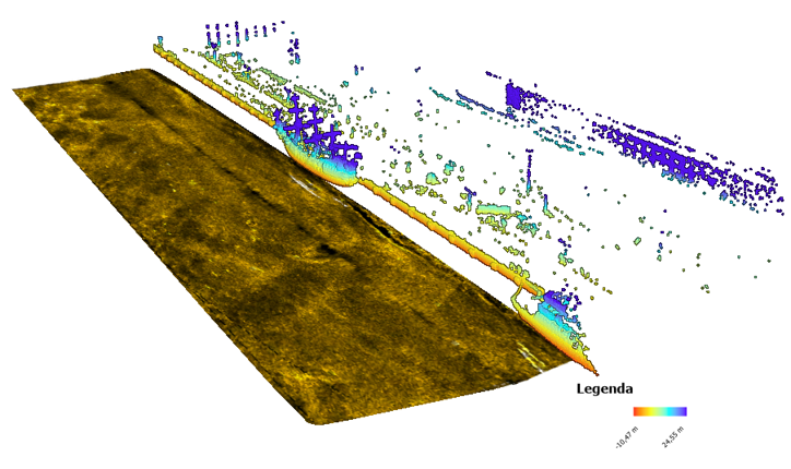
„Autonomous navigation and automatic 3D hydrography system of unmanned floating platform”, 2019 – 2022. The project subject is a significant improvement of the autonomous/remote-controlled multi-purpose surface by developing an autonomous system 3D navigation and automatic hydrography platform. Improved unit could perform measurement missions in the field of bathymetric, sonar and other measurements in autonomous mode by implementing an adaptively planned trajectory and conducting an automatic analysis of 3D measurement data in near real-time included automatic classification of a bottom type, recognition and identification of bottom objects, construction of numerical model of bottom and sonar mosaic and multisensory shoreline extraction to determine the area of permissible maneuvers.
HydroDron
„Development of autonomous/remotely controlled floating platform dedicated to hydrographic measurements in limited waters”, 2016- 2019. Project object was to develop an autonomous / remote-controlled multitasking water platform to the implementation of the hydrographic survey missions in the ports, estuaries, anchorages, bays and lakes, rivers and other restricted areas. As part of the project, an innovative world-class autonomous hydrographic survey platform equipped with state-of-the-art sensors was built.
Research projects financed by the National Research and Development Centert under the LIDER program:
4DShoreMap
„Innovative system for multidimensional and multitemporal monitoring of the coastal zone using an autonomous unmanned vessel”, 2022-2025. The prototype of a multidimensional and multitemporal coastal zone monitoring system using autonomous unmanned floating platforms platforms at a single survey pass.
INNOBAT
„Innovative autonomous unmanned bathymetric monitoring system for shallow water bodies”, 2021-2024. The system enables synchronous bathymetric and LiDAR measurements of ultra-shallow water bodies and the coastal zone from an autonomous floating and flying platform.
SHREC
„Automatic identification and identification system for vessels in waters covered by video surveillance”, 2018-2021. The system allows the process automation of unit recognition, identification of these units as automatic and structured information in the target system and its transmission to other systems the purpose of alerting services about the threat).
MOBINAV
„Mobile Inland Navigation”, 2013-2016. Main scientific purposes was to development of spatial data processing method for needs of mobile cartographic and efficient navigation on inland waterways.
Marine Technology is a leader among companies in the LIDER program. All projects are carried out in accordance with the PRINCE2 methodology.

Fulfillment of the order for services related to research and measurement via an unmanned unit for the project with the acronym MPSS:
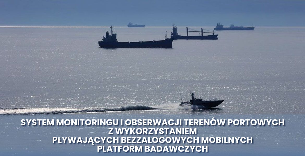
The MPSS project, or the „Monitoring and Observation System for Port Areas Using Floating Unmanned Mobile Research Platforms”, was the first project implemented by the Port of Gdynia Authority SA. with the support of funds that came from the funds of the Norwegian mechanism in the current perspective
The aim of the MPSS project was to determine the possibilities of obtaining accreditation from state administration units for research conducted using surface unmanned platforms and recommendations for the unification of technical standards in this area.
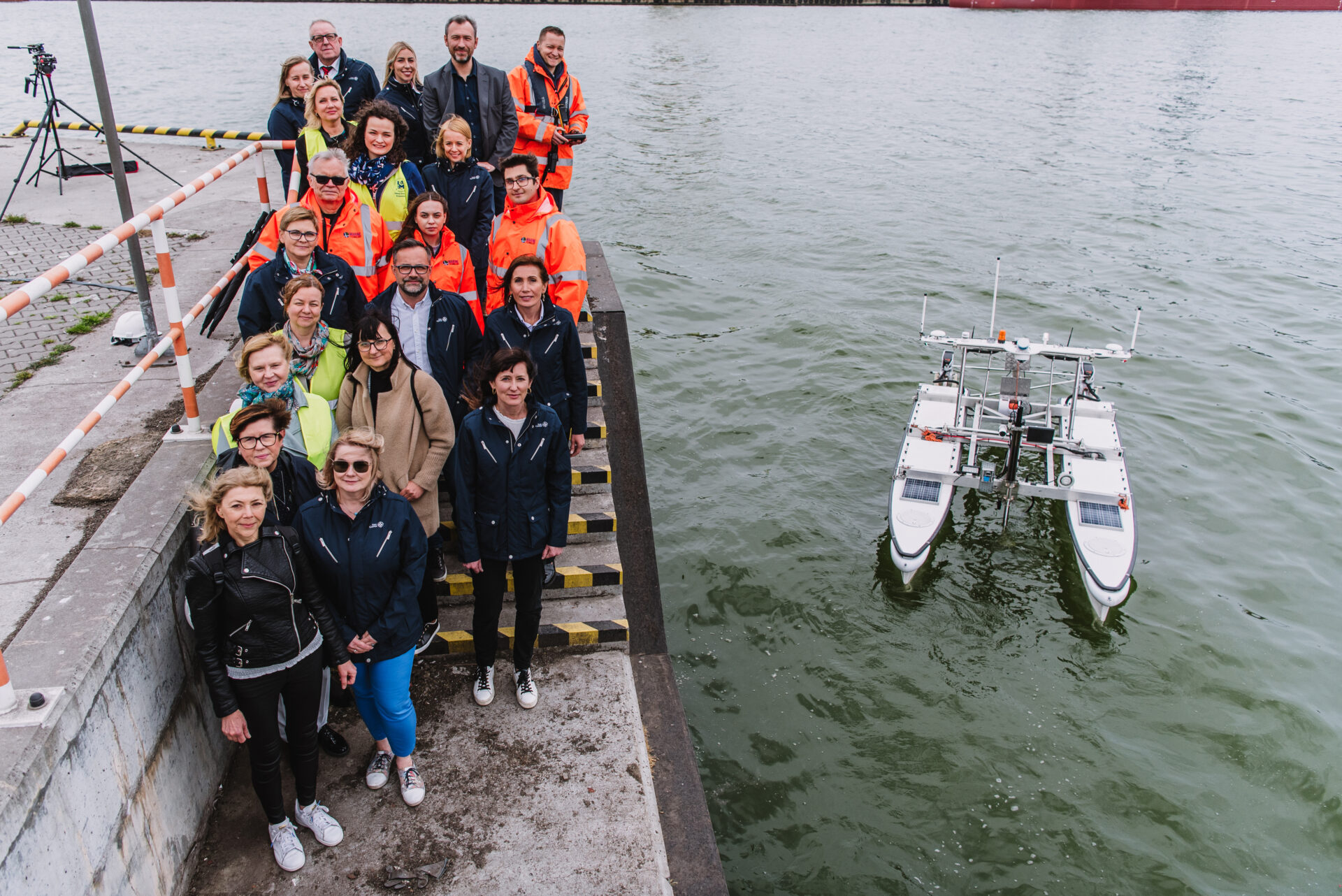
The project involved the use of a mobile research platform in the activities of the Port of Gdynia and includes two very important tasks that were completed by 31 December 2023.
Task 1: Performing hydrographic measurements: bathymetric measurements and sonar surveys in the indicated port waters.
Task 2: Automatic sampling of water (surface and deep seabed) and bottom sediments at designated measuring points and measurements made with the use of a plankton grid at any time of the year.
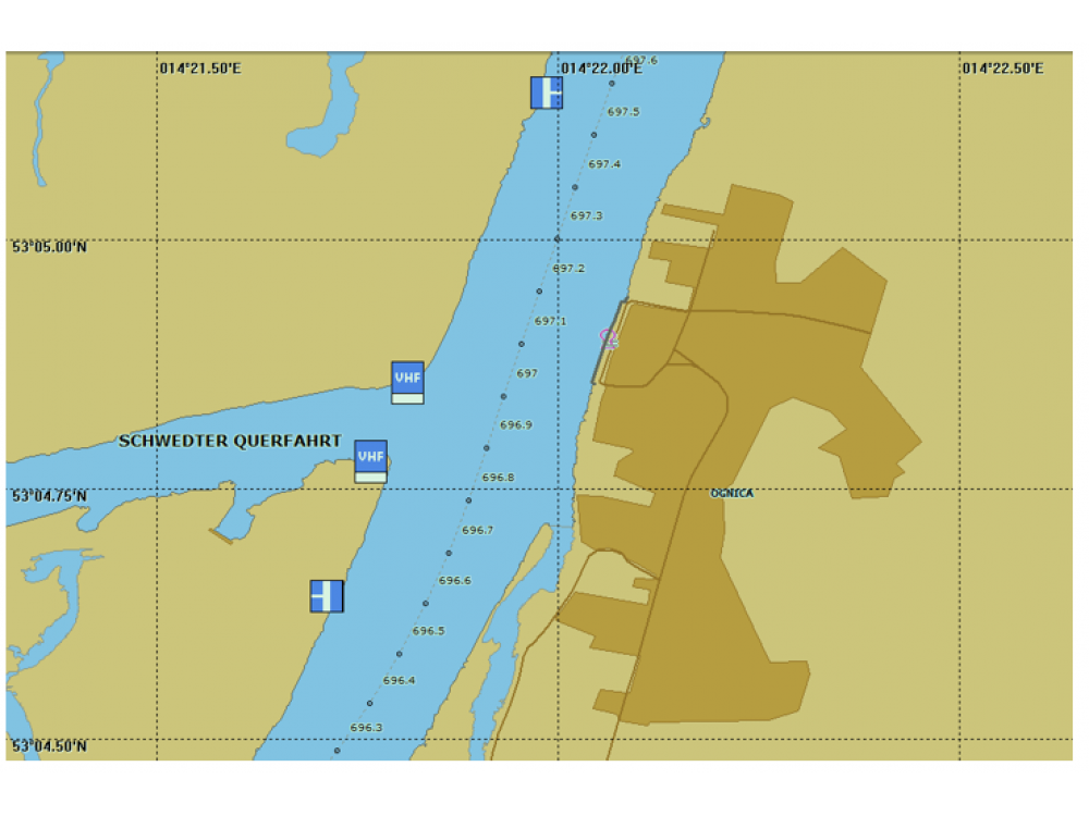
Designing navigation infrastructure in sea and inland waters and many years of research in the field of electronic maps (ENC), including those acquired during the development of the ENC for the River Information System (RIS). Marine Technology performed in 2013. a collection of the first inland ENCs in Poland covering the entire implementation area of the Lower Oder RIS system. These maps have been implemented at the RIS Center.
IENC
A collection of 10 databases of electronic maps, was developed for RIS at Marine Technology Company. Range of map included the shipping lanes from the port of Szczecin to the Ognica.
The Marine Technology company has given the official manufacturer code electronic map, listed in the document IHO S-62 – LIST OF DATA PRODUCER CODES.
Currently, the company has a complete production line and experience, enabling the creation and updating of electronic charts for inland navigation. Scope of the study may include any waterways. In the production of electronic map company can also conduct their continuous updating.

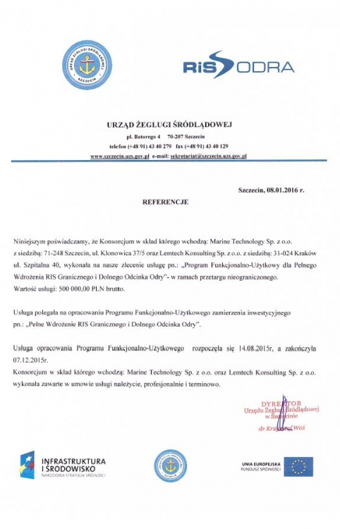
In 2015 alone. a consortium led by Marine Technology has developed a Functional and Utility Program for the Full Implementation of the Border RIS and the Lower Odra (PLN 500,000) at the request of the Inland Navigation Office in Szczecin.
RIS (River Information Services) is a system that aims to improve the safety of navigation and streamline water transport on inland rivers. RIS are information technology (IT) related services designed to optimise traffic and transport processes in inland navigation, i.e. to enhance a swift electronic data transfer between water and shore through in-advance and real-time exchange of information… Czytaj więcej
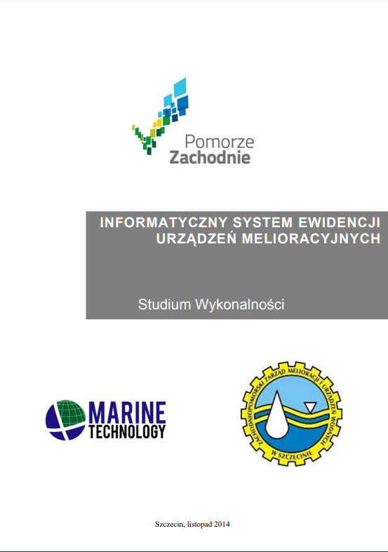
In 2014, a Feasibility Study was developed for the construction of an IT System for Recording Land Improvement Devices with the acronym ISEUM.
As part of the Feasibility Study, the technical and technological feasibility, institutional feasibility, and financial and economic feasibility were described (and discussed in more detail).
The project of developing a concept for the construction of the Information System for the Registration of Land Reclamation Devices (ISEUM) concerned the development of a concept for the construction of the Information System for the Registration of Land Reclamation Devices (ISEUM) based on the existing technological solutions of the West Pomeranian Land Reclamation and Water Facilities Board in Szczecin in the field of electronic records of water, water reclamation devices, and reclamated land.
The company filed the following patent applications:
„Supervision and response system for a collision situation around a small autonomous and unmanned vessel” Pat.240063
„Automatic system for controlling the movement of a vessel in sea, inland and near-sea areas, especially for autonomous and unmanned vessels” P.432992
„System for creating hydrographic omnidirectional and spatial spherical maps using hydroacoustic and optoelectronic techniques” P.436208
„Combined module of unmanned hydrographic units - surface and air for conducting bathymetric measurements of coastal waters, especially coastal shallow waters” P.437942
Many scientific publications have been published with the Marine Technology affiliation, including in Remote Sensing, Sensors, Journal of Navigation, Polish Maritime Research, Information Technology and Control, ISPRS International Journal of Geo-Information and others.
Examples of references:
In 2024, at the request of the Inland Navigation Office in Szczecin, an analysis was carried out to identify the needs for the implementation of the CEERIS system in the area of operation of the RIS system in Poland.
Development of software enabling visualization and processing of sonar data (SONARMUS) along with a set of test data and a report from validation studies (validation of implemented algorithms on sonar data acquired using a USV type unit). Research and development service performed on behalf of the Innovation Center of the Maritime University of Szczecin sp. z o.o.
Development of operational recommendations and operating parameters of the RMode ground-based radio navigation system using the land-based infrastructure of DGPS and AIS stations (2018), i.e. review of normative documents (IMO, IALA, ITU-R etc.) and description of the functionality and range of expected values of the parameters of the designed R-Mode system, its shore stations and the on-board receiver. An analysis of contemporary and historical ground-based radio navigation systems was also developed, which used the principle of radio position measurement based on the distance from reference stations on the shore.
In 2018, at the request of the WWF foundation, tests were carried out using its own 3D sonar, aimed at checking the effectiveness of detecting lost fishing gear with acoustic methods in the waters of the Baltic Sea as part of the international project „Marelitt Baltic”.
In 2013-2015, hydrographic measurements were carried out: bathymetry and sonar during the LNG construction in Świnoujście; before, during and as-built.
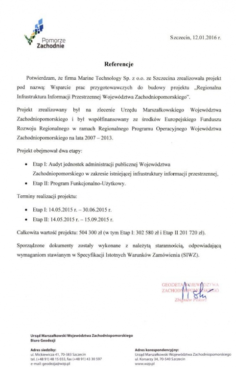
Performing the audit and PFU as part of the construction of the system project „Regional Infrastructure of Spatial Information for the West Pomeranian Voivodeship” (PLN 504 300).
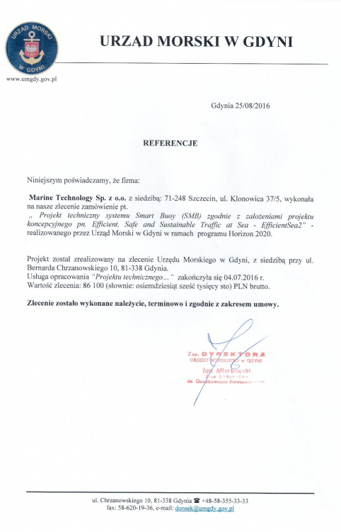
Technical design of the Smart Buoy (SMB) system in accordance with the assumptions of the conceptual project entitled Efficient, Safe and Sustainable Trafic at Sea - EfficienSea 2 financed under the H2020 program and in 2018 „Development of operational recommendations and operating parameters of the R-Mode terrestrial radio navigation system using the land infrastructure of DGPS and AIS stations” for the Maritime Office in Gdynia.
Development of ARPA (Automatic Radar Plotting Aids) and relative maneuvering algorithms for the ARPA system produced by the Industrial Telecommunications Institute (PIT).
Development of tracking algorithms for objects implemented in the Quiet Sea Council produced by the Industrial Telecommunications Institute (PIT).
Development and implementation of the silent marine radar operator interface. Employer: PIT.
Development and implementation of a radar signal recorder at the Naval Academy.
Development of algorithms and software for tactical maneuvering of ships. The effects of the work were implemented in the command system of the Navy ships produced by the Maritime Technology Center.
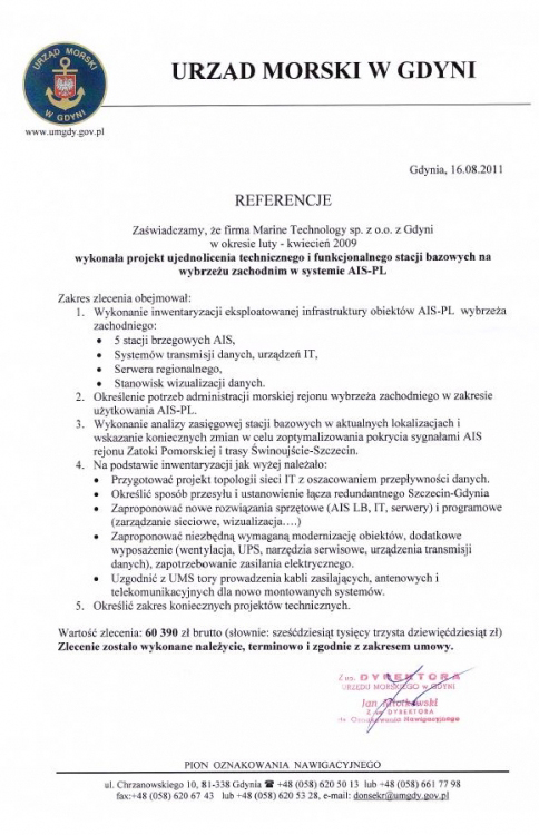
Development of a technical and functional unification project for base stations on the west coast in the AIS-PL system. Employer: Maritime Office in Gdynia.
Examination of the FMCW radar video signal in terms of its possible use in the information fusion process. Ordering party: Gdynia Maritime University.
Development of a navigational analysis for the expansion of the sailing port in Frombork. The work was commissioned by an architectural studio in Gdańsk.
Preparation of a navigational and navigation analysis for the construction of inland marinas in Drewnica and Rybin. Work done on behalf of the architectural studio in Gdansk.
Comprehensive research on the navigation system and management of the armament of ships. Employer: Maritime Technology Center.
Development of the concept of software algorithms that provide information on the radar features of several different impulse and continuous wave radars. Employer: Gdynia Maritime University.
Development of thematic layers of an electronic navigation map of a selected part of the port of Gdynia. Employer: MGGP Aero Sp. z o.o.
Development of assumptions and software for recording survey data. Employer: ShipFox Sc.
Execution and launch of software controlling the movement of the unmanned surface platform in the event of loss of communication with the command post and carrying out software tests in laboratory conditions. Employer: SPORTIS S.A.
Multiple bathymetric measurements of port, inland and marine internal waters in cooperation with the HYDRO-IN company.
Preparation of the laboratory model design of the dynamic positioning system by comparative methods implemented at Naval Academy in Gdynia.
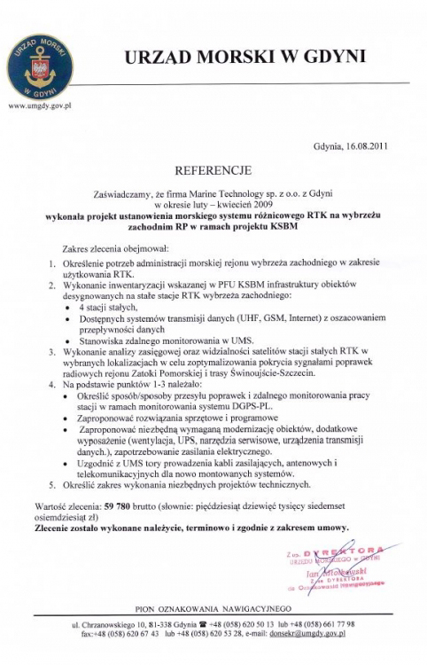
Project to establish the RTK maritime differential system on the west coast of Poland as part of the KSBM project. Employer: Maritime Office in Gdynia.
Development of conditions for the modernization of the infrastructure of the Dziwnów Nautical Station in the aspect of the DGPS-PL shore station function in the National Maritime Safety System-I project.


Address
4/6 Roszczynialskiego St.
81-521 Gdynia
13/5 Niemena St.
81-603 Gdynia
37/5 Klonowica St.
71-248 Szczecin