4DShoreMap
„Innovative system for multidimensional and multitemporal monitoring of the coastal zone using an autonomous unmanned vessel”
This work was supported by the National Centre for Research and Development (NCBR) of Poland under grant no. LIDER/4/0026/L-12/20/NCBR/2021.
Identification of the need for the project
Summarizing the justification of the genesis of the project, it should be stated that the main limitations in the field of coastal zone monitoring are:
– land and hydrographic surveys are carried out and compiled separately: several teams have to collect and process data using different systems;
– the differentiation of the coastal zone makes it difficult to measure from the classic measurement unit;
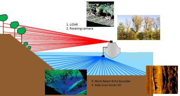
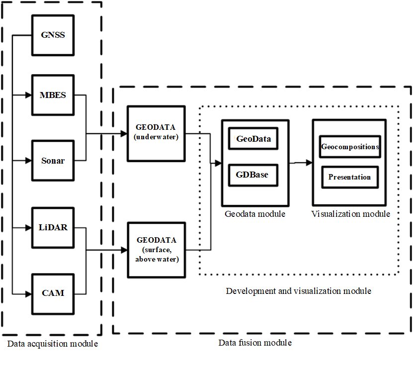
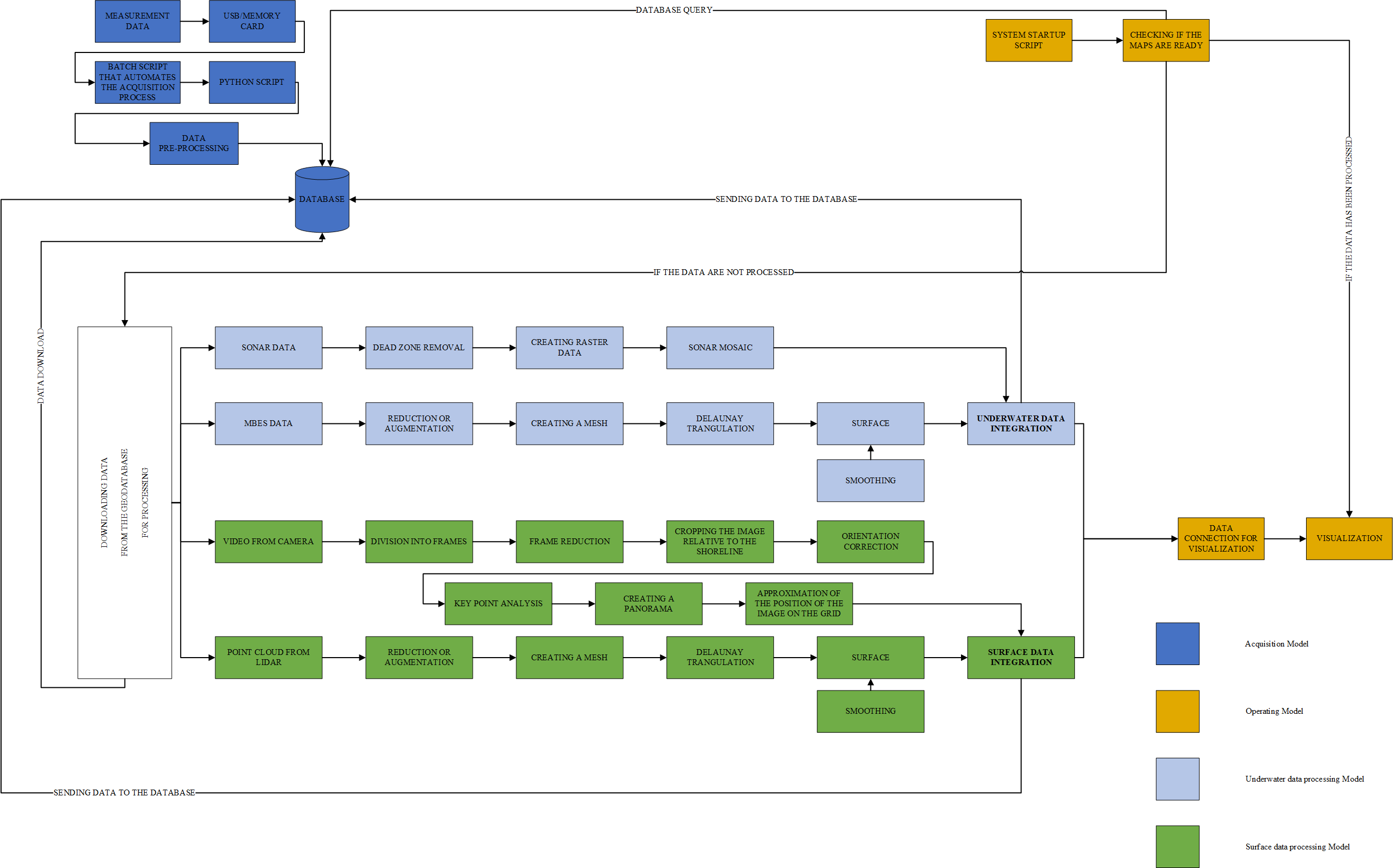
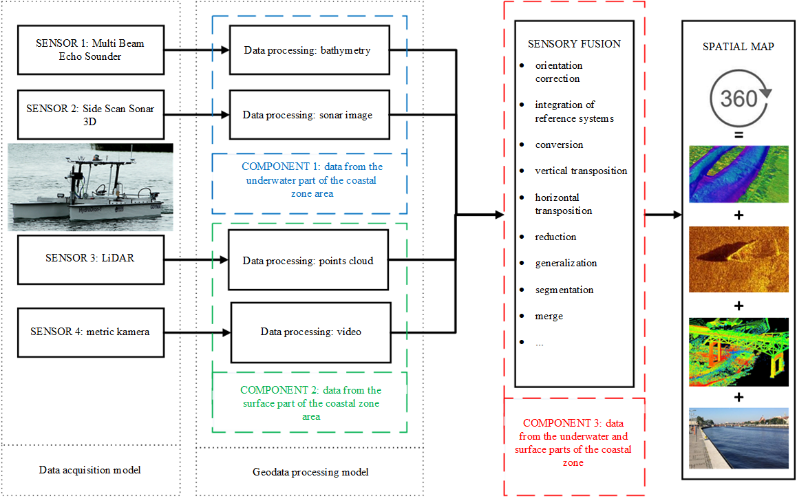
– there is no system that collects and processes data from four different sensors installed simultaneously on the unmanned unit;
– there is a lack of a method that would allow to fully monitor the topography of the coastal zone (both onshore and on the surface) with the use of integrated data visualization (with different characteristics).
Purpose of the project
Development of a prototype of a multidimensional and multitemporal coastal zone monitoring system using autonomous unmanned floating platforms platforms at a single survey pass.
Objective I: developing methodology of using an unmanned vessel for measurements in the coastal zone → configuration of the equipment and devices, way of transmitting information, guidelines for conducting measurements and travel routes.
Objective II: develop methods for processing geodata from four sensors and their fusion → guidelines and standards, characterization of the components of the integrated data module and their fusion (conversion, reduction, fusion, segmentation, rearrangement, orientation correction, transposition, SI application).
Objective III: develop a model for a multi-dimensional and multi-temporal knowledge base on the coastal zone → database model, guidelines and standards for data storage.
Objective IV: development of a model for visualization of integrated data in the form of a spherical spatial map → spherical map containing data from four different sensors, geocomposition components, presentation module.
Potential recipients
– Entities connected with coastal areas by activity profile (e.g. Maritime Offices, Inland Navigation Offices, Regional Water Management Authorities, Port Authorities).
– Entities connected with the location of the coastal area (e.g. Marshal Offices, City Offices, local governments).
– Entities involved in coastal zone inventory and monitoring.
– Designers, investors and contractors carrying out works on sections of waterways.
– Others, such as entities related to the implementation of projects related to geo-information systems.
Address
4/6 Roszczynialskiego St.
81-521 Gdynia
13/5 Niemena St.
81-603 Gdynia
37/5 Klonowica St.
71-248 Szczecin